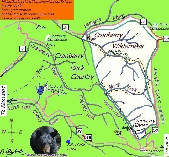
The Cranberry Wilderness is bounded on the west by the Cranberry Backcountry and on the east by the Highlands Scenic Highway. Maps available at the Cranberry Mountain Visitor Center or any of the USFS ranger stations shows trails and gated roads that provide access to the heart of the wilderness and backcountry.
Hiking/Backpacking/Camping/Hunting/Fishing/Cross-Country Skiing/Wildlife Viewing:
Reality check:
Know your location.
Get the latest National Forest Map (A good companion to help you get to where you're going)
Take a compass or a GPS
Bring along extra safety items such as water, flashlights, and a cellphone or radio
Check with local forest agents to see what precautions need to be taken in regard to storing food away from wildlife
Do not feed the local wildlife
Be courteous and remember that you are sharing public lands with other.
| Richwood |  | WV. |
Copyright © © Background 2005 By [Billybob]
Richwooders provides no warranty, nor accepts any liability occurring from any incorrect, incomplete, data, or from any incorrect, incomplete, or misleading use of these data. It is the sole responsibility of the user to determine whether or not the data are suitable for the intended purpose. |