Richwood, West Virginia - Map

Click on Bald Eagle for enlargement.
What a Country!
Maps
Map Of  WV Click for  a More Detail Map of Richwood Nicholas County WV Click for  a More Detail Map of Richwood

          Second Map     Third Map     Map Index
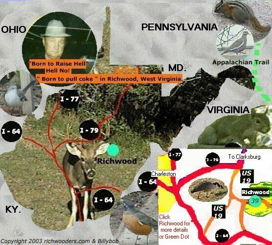
   Nickname:     Mountain State
   Land Area:    24,124 sq. mi.
   Highest Point: Spruce Knob, 4,861 ft.,
   Capital:          Charleston
   Largest City:  Charlieston

HomeRichwood (Site)

Back to TopTOP

First of two Maps of Richwood West Virginia - Richwood Map

Richwoodwww.richwooders.comMaps

Copyright 1997 @ 2003 Billybob. No part of this web page may be reproduced or distributed without the express written consent of Billybob or www.richwooders.com.Richwood,West Virginia, Maps
   |  Home  Aerial Photography, 2006  How to Link To Us Contact Pictorial Book New Photos (2005) WANTED 
4 Seasons,Richwood Picture Book Postcards Nov. 19 2003 Flood Richwood Flood '54  Richwood Blizzard '93 
Dain Grade School Fenwick Grade Sch. Little Laurel School Milltown Grade Sch. Richwood Grade School 
Southside Grade Sch Tannery Grade School Walnut St. Grade School Lodging Restaurants Richwood  
Richwood WV Churches Maps  Attractions near by Search Richwooders Links ( to Other sites ) 
Airport
 Ramps 1932 Flood Wildlife Nancy Hart Coal Mining Table of Contents  | 
Nickname:Mountain State,Land Area:24,124 sq. mi.,Highest Point: Spruce Knob, 4,861 ft.,Capital: Charleston, Largest City: Charlieston

Back to Top

Buy American whenever you can
Your Choices Make all the difference.